
SDX-Compact Series
Turn your construction machine to an automated surveying tool.
The SDX-Compact mounts directly to earthmoving equipment and turns every pass into a survey. Combining LiDAR scanning and GNSS positioning, it captures site data automatically the moment the machine is in operation and makes it available in the office in real time.
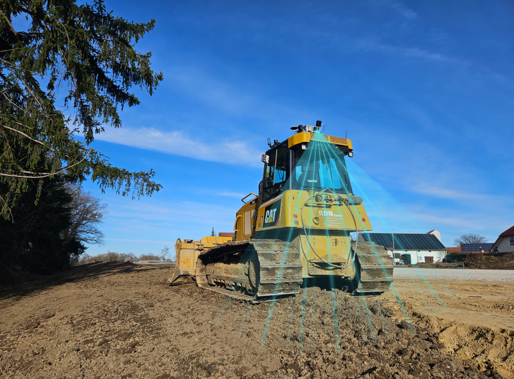
SDX-Compact – Built For Earthmoving
As the construction machine operates, the SDX-Compact continuously scans the surrounding terrain and uploads topographic data wirelessly to SDX-Cloud
every 10 minutes or at other user-defined intervals. You get as-built documentation without a dedicated survey crew and without interrupting anyone’s day.
There’s no calibration required, and installation takes minutes before it’s ready to go. The unit moves between machines easily, so a single system can follow the work rather than sit idle on a parked machine.
Your machines work every day and cover every inch of the site. The SDX-Compact turns that coverage into data, delivering two jobs at once as surveyors no longer need to travel to the site for as-built data collection.
Cut and fill volumes update throughout the day, giving project managers a live picture of progress against plan. Terrain is compared against design models automatically, so over-excavation and under-compaction get caught early. Variances surface while they’re still cheap to fix, not weeks later at the final walkthrough when rework costs real money.
Earthmoving and site prep

Road Construction

Landfill Management

General terrain surveying
SDX-Compact OnTop — Built for Stockpiles and 360° Coverage
The SDX-Compact OnTop mounts to the machine’s roof using magnetic base plates and captures a full 360° view at around 130 ft. That all-around coverage matters when the material you need to measure is on every side of the machine, not just behind it.
Ideal for automated stockpile monitoring, the SDX-Compact OnTop generates real-time data from your aggregate sites, eliminating surveyor travel times and data processing delays.
The flexibility and ease of use of the SDX-Compact OnTop make it ideal for short-range mobile mapping applications like streets, neighborhoods, and airport environments, delivering high-resolution 3D data models with colorized point clouds from the on-board cameras. It’s also a reliable alternative to drones in areas with flight restrictions or unpredictable weather conditions.
Dashboards in SDX-Cloud display the metrics you care about, and dashboard links and
customizable reports can be shared across your organization, so the person doing the billing has the information needed at hand.


Stockpile measurement and volume tracking

Quarry and aggregates operations

Mobile Mapping

Areas with drone restrictions
Two Configurations. One System.
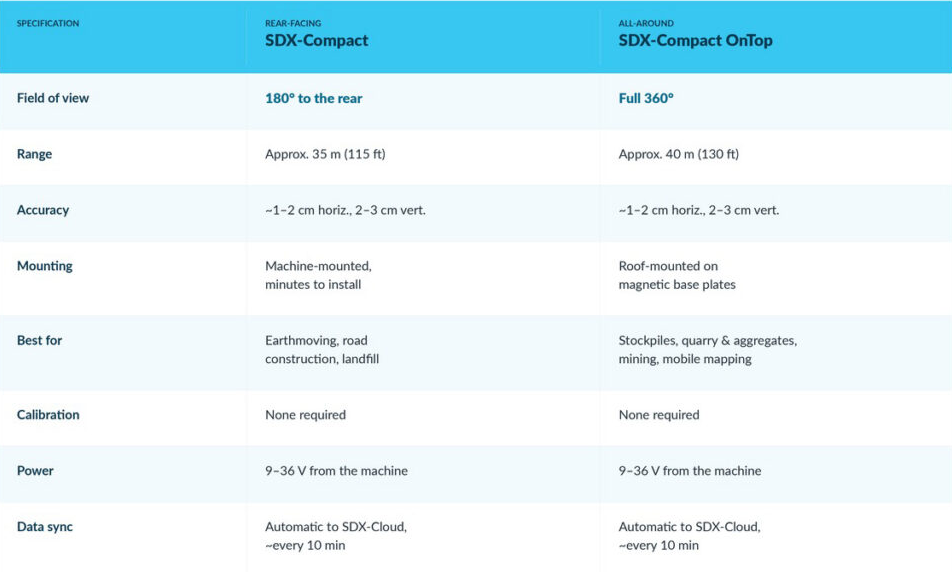
Which one do you need?
If your machine drives across the ground it’s documenting — dozers cutting grade, scrapers, road work — the standard SDX-Compact’s rearward view captures exactly what you just built. If the material you need to measure surrounds the machine rather than trailing behind it, the OnTop’s 360° coverage is the right call.
Machine Compatibility
Both configurations are designed for loaders, dozers, and other earthmoving equipment. For smaller trenches or tight project areas inaccessible to machines, the SDX-PocketScan handheld scanner is an ideal solution to close any documentation gaps.
CONTACT US